

Categories


News & Event
Super Typhoon Kalmaegi 2025: Forecast, Analysis, and Comprehensive Preparation Guide
A detailed analysis of Super Typhoon Kalmaegi 2025: forecast track, intensity, potential impacts, and a comprehensive guide to ensure safety for you and your family.
As climate change becomes increasingly evident, extreme weather events are becoming more frequent and intense. Each year, we face devastating typhoons, and 2025 is predicted to be no exception. One name drawing special attention from international meteorological centers is Kalmaegi – a potential cyclone that could develop into a super typhoon, directly threatening the safety and livelihoods of millions. This article provides a comprehensive overview of Super Typhoon Kalmaegi 2025, from early forecast analyses and potential impact assessments to detailed and urgent preparation guidelines.
What is Typhoon Kalmaegi? History and Forecast for 2025
The name "Kalmaegi" (Korean for "seagull") is not unfamiliar in the list of typhoons in the Northwest Pacific region. Historically, several typhoons have borne this name, with varying degrees of impact. However, early forecast models for 2025 paint a concerning picture. Based on factors such as unusually high sea surface temperatures (SST) in the Philippine Sea and the influence of atmospheric cycles like El Niño/La Niña, experts believe that Kalmaegi 2025 has the perfect conditions for rapid intensification.
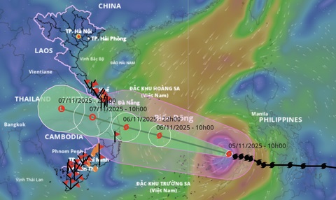
Initial forecasts suggest the storm is likely to form around the end of the third quarter or the beginning of the fourth quarter of 2025, a peak period for Vietnam's typhoon season. The potential formation area is east of the Philippines, a notorious "typhoon alley" that provides abundant energy from the warm ocean. From there, its trajectory could head straight towards the South China Sea (known in Vietnam as the East Sea), putting coastal areas of Vietnam, especially the Central region, on high alert.
In-depth Analysis of Projected Track and Intensity
While it is too early to determine the exact track, global forecast models (like GFS and ECMWF) have presented several plausible scenarios. The most worrying scenario is that Typhoon Kalmaegi will move in a west-northwest direction, cross the Philippines, and enter the South China Sea as a very powerful storm. Once in the South China Sea, with favorable conditions, it could reach super typhoon status (Category 4 or 5 on the Saffir-Simpson scale), with sustained wind speeds potentially exceeding 220-250 km/h (137-155 mph), and gusts over 280 km/h (174 mph).
The factors determining the storm's path include the behavior of the subtropical Pacific high-pressure system. If this high-pressure ridge is strong and extends westward, it will "steer" the typhoon deep into Vietnam's mainland. Provinces from Quang Binh to Binh Dinh are considered the highest-risk areas for direct impact. In addition to terrifying winds, Kalmaegi could also bring other hazards such as a storm surge of 5-7 meters and extreme rainfall, potentially reaching 500-800mm in a short period, causing widespread flash floods and landslides.
Potential Impacts of Super Typhoon Kalmaegi 2025
A super typhoon like Kalmaegi can cause catastrophic consequences on multiple fronts. Identifying these impacts early is the first step in building an effective response plan.
- On People and Communities: The greatest threat is to human life. Large-scale evacuations will be mandatory. Coastal communities could be isolated, facing the loss of homes, and shortages of food and clean water. The post-disaster psychological impact is also a serious concern.
- On Infrastructure: Extreme winds can destroy homes, public buildings, schools, and hospitals. The power grid and communication networks could be completely paralyzed. Roads and bridges could be severely damaged by floods and landslides, hampering rescue efforts.
- On the Economy: Agriculture will suffer heavy losses, especially in rice-growing regions, croplands, and coastal aquaculture. Tourism, a key economic pillar for many central provinces, will be brought to a standstill. Industrial production will also be affected due to supply chain disruptions and factory damage.
- On the Environment: Storm surge will cause deep saltwater intrusion, affecting agricultural land. Severe coastal erosion will occur. Sensitive ecosystems like coral reefs and mangrove forests could be devastated, taking many years to recover.
A Comprehensive Preparation Guide: Before, During, and After the Storm
Thorough preparation is the key to minimizing damage. Every individual, family, and community needs a clear action plan.
Before the storm arrives:
- Stay Informed: Regularly follow weather forecasts from official sources such as the National Center for Hydro-Meteorological Forecasting, television, and radio stations.
- Secure Your Home: Reinforce your roof, windows, and doors. Trim large tree branches that could fall. Move outdoor objects indoors.
- Prepare an Emergency Kit: Include a flashlight (and extra batteries), a radio, a first-aid kit, necessary medications, drinking water, and non-perishable food for at least 72 hours.
- Plan Your Evacuation: Identify a safe evacuation route and the nearest shelter. Discuss the plan with family members. Fully charge your phone and power banks.
- Protect Important Documents: Place personal IDs and important papers in waterproof bags.
During the storm:
- Stay Indoors: Do not go outside under any circumstances. Find the safest shelter in your home, usually an interior room without windows.
- Stay Away from Glass: Windows and glass doors can shatter from high winds or flying debris.
- Unplug Appliances: Unplug non-essential electronics to prevent power surges from lightning or flooding.
- Monitor Information: Continue to listen for updates on a battery-powered radio.
After the storm has passed:
- Be Cautious When Going Outside: Wait for the official all-clear. Be aware of hazards like downed power lines, fallen trees, and damaged structures.
- Inspect Your Home: Carefully assess the damage. Take photos as evidence for insurance claims.
- Do Not Use Tap Water Until Declared Safe: The water supply may be contaminated.
- Connect with Your Community: Help your neighbors, especially the elderly, people with disabilities, and children.
Super Typhoon Kalmaegi 2025, while still a forecast, serves as a powerful reminder of the need for proactive disaster preparedness and response. Climate change is making worst-case scenarios more plausible. By equipping ourselves with knowledge, building plans, and taking decisive action from the government level down to individual households, we can mitigate the loss of life and property and protect our communities from the force of nature. Start preparing today for the safety of yourself and your loved ones.
Comments
Tin tức khác

Horoscope for Earth Horse 1978 Male in 2026 (Year of the Fire Horse)

How to Use a Hydrating Serum for Your Skin in the Summer

A Complete Guide: How to Use a Hydrating Serum for Winter Skin